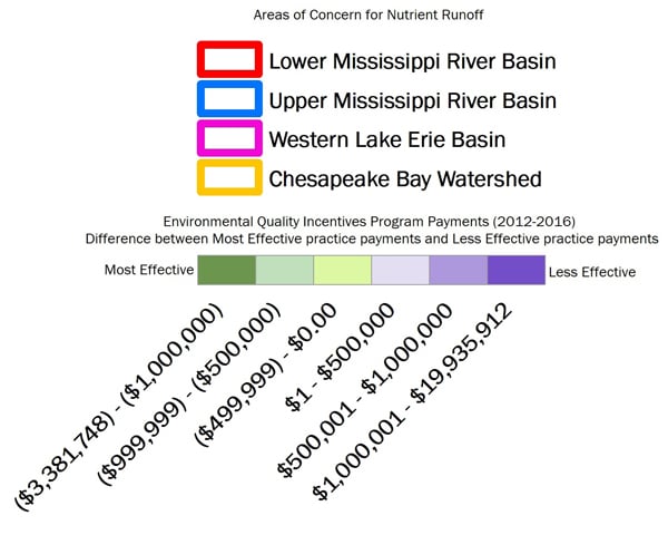


Payment, contract and practice data were derived from the U.S. Department of Agriculture’s Environmental Quality Incentives Program from 2012 to 2016. All data reflect contracts with certified payments, and with active or completed status with the Natural Resources Conservation Service.
Data reflecting Less Effective practices include the following practices and practice codes specifically listed in S. 2624:
Access Road (560), Animal Mortality Facility (316), Aquaculture Ponds (397), Clearing and Snagging (326), Dam (402), Dam, Diversion (348), Dike (356), Diversion (362), Fish Raceway or Tank (398), Irrigation Pipeline (430), Irrigation Reservoir (436), Land Clearing (460), Land Smoothing (466), Livestock Pipeline (516), Obstruction Removal (500), Pond (378), Pumping Plant (533), Spoil Spreading (572), Surface Drain, Field Ditch (607), Surface Drain, Main or Lateral (608), Vertical Drain (630), Waste Facility Closure (360), Waste Storage Facility (313), Waste Transfer (634), Waste Treatment Lagoon (359).
A detailed analysis of Less Effective practices is available here.
Data reflecting Most Effective practices include the following practices and practice codes specifically listed as high-priority practices in S. 2624:
Conservation Cover (327), Conservation Crop Rotation (328), Cover Crop (340), Critical Area Planting (342), Filter Strip (393), Nutrient Management (590), Prescribed Grazing (528), Residue and Tillage Management, No-Till (329), Riparian Forest Buffer (391), Riparian Herbaceous Cover (390), Tree/Shrub Establishment (612).
A detailed analysis of Most Effective practices is available here.
Basins displayed on the map are approximate, and meant to visualize the areas in which agricultural runoff is negatively impacting surface water quality. The boundaries are generalized areas meant to show all contributing drainage areas for a specific river, lake or bay. Locations were derived using the U.S. Geological Survey’s hydrologic units and capture the following watersheds: the Chesapeake Bay watershed, Western Lake Erie basin, Upper Mississippi River basin and Lower Mississippi River basin.